It's an excellent read, and very stimulating to thought and further exploraration. He has a particular fondness for Ordnance Survey maps of the UK, but also covers local maps, rude street names, etc - and all the way out to world maps.
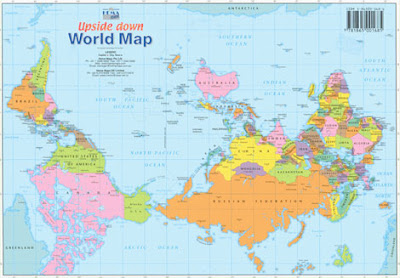
I felt sorry that in discussing world maps, where he pointed out the limitations of both the Mercator projection (with which we all feel familiar, in spite of its distortions of land size) and the Peters projection (which gets areas right, but appears downright ugly, and distorts the shapes of the landmasses - terribly PC and all that, but horrible). We traditionally draw these with The Atlantic in the middle, which emphasises the apparent importance of Europe and the USA, and with North at the 'top', which also has political implications. The Upside Down map created by someone from OZ certainly exercises the mind.

Of course, it perpetuates the misleading idea of 'up and down' which Bucky so disliked (in Cosmos you only find 'in' (coming in to land on a planet) and 'out' (he suggests you should think of looking out at the stars, not 'up').

Bucky Fuller's Dymaxion map may look very unfamiliar (and seeing things afresh might prove important in itself) but it does not distort landmass area or shape, it does not have any up or down, north, south, east or west, and it can actually be folded to make a good simulation of a globe (unlike any other flat map).
As Bucky disliked the idea of nation states, he preferred that his map of Spaceship Earth not get divided with national or political lines, and so, for all its value, it has not been adopted by the United Nations...or many people, indeed, who still prefer the misleading map they grew up with.
Similar discussions could follow, on how resistant we can all prove to any kind of change to the models and maps we use to simplify and understand the world. Changes in language can perhaps align us better with the world out there, as Bucky suggested (teaching your children about sunrise and sunset continues the incorrect perception of the sun going around the Earth, for instance, so he suggested sunsight and sunclipse...and how about 'going outstairs' and 'instairs'! :-)
Not sure if animated GIFs work in Blogger, so here you will find the link to bring this pic alive!

However weird some of his suggestions, they seem clearer than people in the Northern Hemisphere thinking of Australians as 'being upside down'. But hey, I don't hold my breath waiting for such quirky uses of language to catch on. Not until we have spent some time in space stations, at least.
Bucky artefacts at Artsy [updated Oct 2016]
No comments:
Post a Comment